

B.C. flooding, mudslides prompt evacuation orders, highway closures in the Interior
Advertisement
Read this article for free:
or
Already have an account? Log in here »
To continue reading, please subscribe:

Digital Subscription
One year of digital access for only $205*
- Enjoy unlimited reading on winnipegfreepress.com
- Read the E-Edition, our digital replica newspaper
- Access News Break, our award-winning app
- Play interactive puzzles
*First annual payment billed as $205.00 + GST for one year. This annual subscription will automatically renew at $233.00 + GST every 52 weeks (10% off the regular annual price of $259.35). Offer available to new and qualified returning subscribers only. Cancel any time.
To continue reading, please subscribe:
Add Free Press access to your Brandon Sun subscription for only an additional
$1 for the first 4 weeks*
- Enjoy unlimited reading on winnipegfreepress.com
- Read the E-Edition, our digital replica newspaper
- Access News Break, our award-winning app
- Play interactive puzzles
*Your next Brandon Sun subscription payment will increase by $1.00 and you will be charged $17.95 plus GST for four weeks. After four weeks, your payment will increase to $24.95 plus GST every four weeks.
Read unlimited articles for free today:
or
Already have an account? Log in here »
Hey there, time traveller!
This article was published 04/05/2023 (1232 days ago), so information in it may no longer be current.
A “rapid transition” into spring with a week of record-setting temperatures has accelerated mountain snowmelt, a provincial forecaster said, leading to flooding and mudslides throughout British Columbia’s central and southern Interior.
Dave Campbell, the head of B.C.’s River Forecast Centre, said the problems will be compounded by heavy rains and possible thunderstorms expected this weekend.
“This is really going to add additional run-off to the rivers that are already high from the snowmelt. So, in areas where we already have issues related to flooding, we do anticipate we could see exacerbation of those conditions,” he told a news conference hosted by the Ministry of Emergency Management on Thursday.
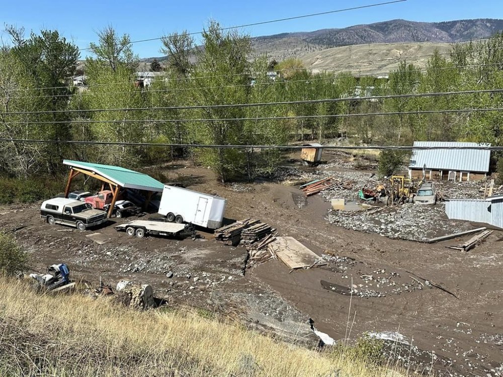
“We can also expect to see new areas coming online as rivers are challenged with additional run-off coming from the snowmelt and rainfall.”
Flood warnings, lower-level flood watches or high streamflow advisories cover much of the province’s southern and central Interior.
The B.C. government has said conditions in areas that are currently flooding, including Cache Creek and Okanagan Indian Band territory, were expected to deteriorate, while “moderate flooding” was likely in Grand Forks starting Friday.
“Unfortunately, it is likely that some of these communities are going to see conditions get worse in the immediate short term before they get better,” Emergency Management Minister Bowinn Ma told media on Thursday.
Sandbags and other barriers have been deployed to communities that are at risk, she said.
Ma said the province is aware of seven evacuation orders and six evacuation alerts across B.C., but warns that “it is a dynamic situation that is quickly evolving.”
The number of properties under evacuation order in Cache Creek ticked up to 13 from five on Wednesday. Mayor John Ranta said one home is likely lost.
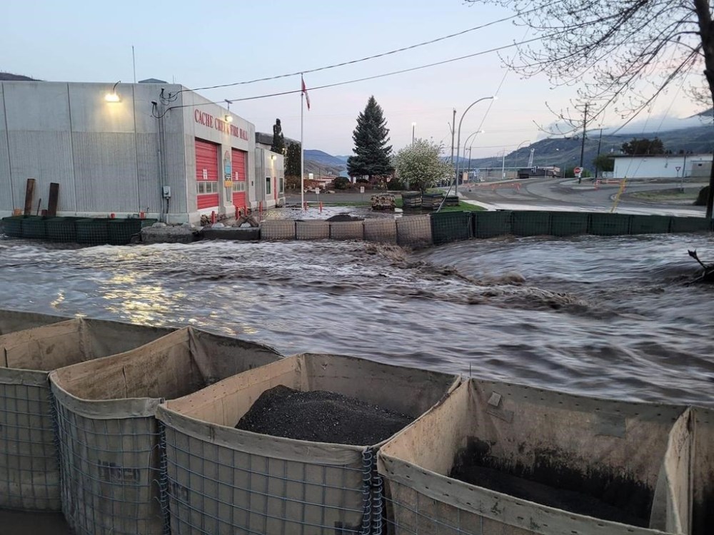
It was “unbelievable the amount of water” that was flowing over Highway 97 and down Highway 1 as the two routes intersect in the village west of Kamloops, Ranta said in an interview on Thursday.
Many businesses have been devastated by the flooding, and the floodwaters were running through the firehall, he said.
The mayor said he’s spoken with Ma, who offered support from the province, and several BC Wildfire Service crews are in the village to help distribute sandbags.
But Ranta said there’s nothing they can do until the waters recede, then take steps to prevent similar extensive flooding from happening in the future.
Temperature records were broken in 10 B.C. communities Wednesday, including several where flooding is a risk. Yoho National Park reached 25.3 C, more than three degrees above the record set back in 1923.
The Okanagan Indian Band expanded an evacuation order for properties along Okanagan Lake in the community of Parker Cove, where it said floodwaters from Whiteman Creek have eroded land and undercut trees.
An update posted on the Grand Forks website said local fire crews were working on a temporary dam nearly 460 metres long to protect one of areas that’s most vulnerable to flooding in the community near the Canada-U. S. border.
The Regional District of Kootenay Boundary has declared a state of local emergency and issued an evacuation order for 10 properties in Grand Forks as water levels rise on the Kettle River.
Grand Forks Mayor Everett Baker said Thursday his community has been preparing for the wet weather expected this weekend.
Baker said the city has received temporary dams, sandbags and other assets from the province to prepare for flooding, with past events top of mind after Grand Forks lost nearly a hundred homes to a flood in 2018.
He said crews are concentrating efforts to protect homes, businesses, and infrastructure in the city’s downtown, while properties in the outlying areas are harder to support and those living there are aware they are on a floodplain.
Baker said his daughter lost her home in the last major flood event, so he’s keenly aware of the stress of another potential disaster.
“That’s why I know myself and council and our city staff decided this time that we were going to try to be as proactive as possible and get out the protection that we can sooner than later,” he said. “Then hopefully we’ll have done enough to protect the city.”
Meanwhile, the Regional District of Central Kootenay has put three more properties on evacuation alert in response to a landslide and debris flowing from Talbot Creek in the community of Vallican, where photos shared by the district show the water has carved a deep channel through Little Slocan South Road.
Another mudslide has forced the closure of an 80-kilometre stretch of Highway 3 between Salmo and Creston, causing longer wait times for the Kootenay Lake ferry.
Highway 3 is also closed in both directions due to flooding about 15 kilometres east of Castlegar, while a short stretch of Highway 99 is closed due to flooding about 67 kilometres north of Lillooet, with assessments underway in both areas.
This report by The Canadian Press was first published May 4, 2023.