Is hurricane Lee headed for Canada? The ‘spaghetti models’ can be misleading: expert

Advertisement

Advertise with us

HALIFAX - For residents of Canada's East Coast, some of the latest images showing the potential path northward for hurricane Lee are disturbing.

Read this article for free:


or

Already have an account? Log in here »

To continue reading, please subscribe:

Subscribe and receive a limited-edition Free Press branded hat or tote.

Digital Subscription

One year of digital access for only $205*

  • Enjoy unlimited reading on winnipegfreepress.com
  • Read the E-Edition, our digital replica newspaper
  • Access News Break, our award-winning app
  • Play interactive puzzles

*First annual payment billed as $205.00 + GST for one year. This annual subscription will automatically renew at $233.00 + GST every 52 weeks (10% off the regular annual price of $259.35). Offer available to new and qualified returning subscribers only. Cancel any time.

To continue reading, please subscribe:

Add Free Press access to your Brandon Sun subscription for only an additional

$1 for the first 4 weeks*

  • Enjoy unlimited reading on winnipegfreepress.com
  • Read the E-Edition, our digital replica newspaper
  • Access News Break, our award-winning app
  • Play interactive puzzles
Start now

*Your next Brandon Sun subscription payment will increase by $1.00 and you will be charged $17.95 plus GST for four weeks. After four weeks, your payment will increase to $24.95 plus GST every four weeks.

Hey there, time traveller!
This article was published 08/09/2023 (1066 days ago), so information in it may no longer be current.

HALIFAX – For residents of Canada’s East Coast, some of the latest images showing the potential path northward for hurricane Lee are disturbing.

By combining multiple computer-generated forecasts, meteorologists have produced maps of the western Atlantic Ocean that suggest the powerful storm could slam into the Maritimes late next week.

But Chris Fogarty, program manager at the Canadian Hurricane Centre in Halifax, says these long-range models are of little value at this stage.
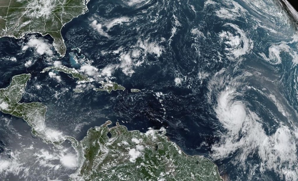
Residents of Canada's East Coast are keeping a close watch on hurricane Lee. Recently released computer-generated forecasts suggest the powerful storm is headed for the Maritimes late next week. But an expert says these long-range 'spaghetti' models are of little use at this stage. This Wednesday, Sept. 6, 2023, satellite image provided by the National Oceanic and Atmospheric Administration shows Hurricane Lee, right, off in the central tropical Atlantic Ocean. (NOAA via AP)

Fogarty says these spaghetti models — so called because the layers of predicted tracks look like splayed noodles — don’t adequately represent the broad range of possible forecasts.

“In the case of Lee, these maps are not very useful beyond about five days because the noodles can become very scattered and confusing,” he said Friday in an email.

“Beyond about five days — depending on the degree of chaos in the atmosphere — they can appear more focused than they should be. At those long time ranges, they don’t usually depict the (full) range of possible tracks.”

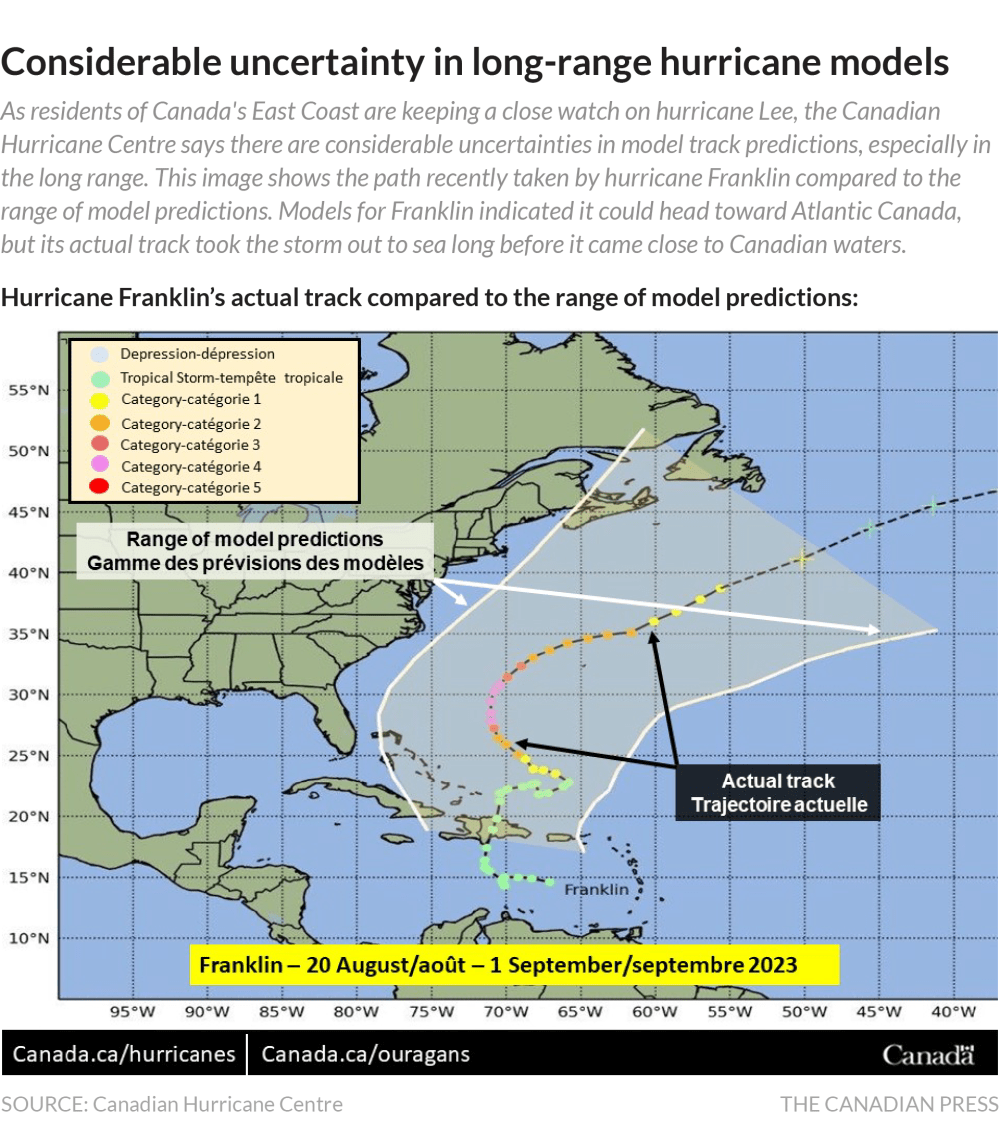
As an example, Fogarty pointed to the path recently taken by hurricane Franklin earlier this month.

The 10-day spaghetti model for Franklin also indicated it would head toward Atlantic Canada, but its actual track took the storm out to sea long before it came close to Canadian waters.

“The plots for Franklin showed numerous track possibilities, but the actual track occurred outside many of the predictions,” Fogarty said. “So that was an example of how they can be misleading.”

Earlier in the week, the hurricane centre posted an image on social media showing the difference between the 10-day prediction and Franklin’s actual track, saying it provided “a stark reminder of the considerable uncertainties in model track predictions.”

Fogarty said the centre uses spaghetti models in its computer analysis, but the models are not displayed on Environment Canada’s website. “We don’t display them in our tweets either,” he said, adding that the diagrams “can confuse the lay viewer.”
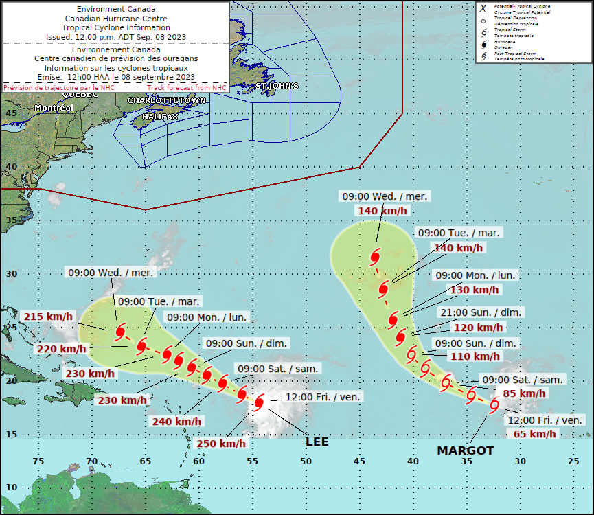
The Canadian Hurricane Centre produces its own online hurricane track map, which provides a five-day forecast.

As Lee churned through the northeast Caribbean on Friday, it became the first Category 5 storm of the hurricane season before it lost some of its strength and was downgraded to Category 4 with sustained winds reaching 250 kilometres per hour.

Category 5 hurricanes produce devastating winds in excess of 252 kilometres per hour, while Category 4 storms generate winds reaching at least 209 kilometres per hour, which can also cause catastrophic damage to buildings and trees.

The National Hurricane Center in Miami issued a public advisory Friday saying Lee would remain a powerful hurricane into next week as it passes north of the Virgin Islands and Puerto Rico.

“Some fluctuations in intensity are likely over the next few days,” the American agency said. “Hurricane-force winds extend outward up to (55 kilometres) from the centre and tropical-storm-force winds extend outward up to (220 kilometres).”

Large swells generated by Lee were expected to reach the British and U.S. Virgin Islands, Puerto Rico, Haiti and the Dominican Republic, the Turks and Caicos Islands, the Bahamas and Bermuda this weekend.

“Dangerous surf and rip currents are expected to begin along most of the U.S. East Coast beginning Sunday,” the advisory said.

Lee is the 12th named storm of the Atlantic hurricane season, which runs from June 1 to Nov. 30 and typically peaks in September.
“It is way too soon to know what level of impacts, if any, Lee might have along the U.S. East Coast, Atlantic Canada or Bermuda late next week,” the U.S.-based hurricane centre said.

Meanwhile, tropical storm Margot became the 13th named storm after forming Thursday evening well east of Lee. Margot was forecast to strengthen into a hurricane over the weekend but was expected to remain far from Canada and the United States.

This report by The Canadian Press was first published Aug. 8, 2023.

— With files from The Associated Press

Report Error Submit a Tip

More Stories

Gilbert Plains Country Club closes for remainder of season due to flood damage

Ken Wiebe 6 minute read Preview

Gilbert Plains Country Club closes for remainder of season due to flood damage

Ken Wiebe 6 minute read Thursday, Aug. 6, 2026

Scott McCallum has made the trek to the Gilbert Plains Country Club clubhouse countless times.

But this was the first time the golf professional and general manager of the course required hip waders to get to his office.

Walking hand in hand with his wife Lindsay, McCallum didn’t need much time to see the devastation caused by the flash flooding in the Parkland region in late June.

“We’re on a river and it’s a beautiful golf course, but anytime you’re on a body of water you know that you’re taking a chance of events like this happening,” McCallum said in a telephone interview. “To this magnitude, we’ve never seen anything like it before. So, this is new to us.

Read
Thursday, Aug. 6, 2026

Hurricane Lee's track: models can be misleading

Michael MacDonald, The Canadian Press 4 minute read Preview

Hurricane Lee's track: models can be misleading

Michael MacDonald, The Canadian Press 4 minute read Friday, Sep. 8, 2023

HALIFAX - For residents of Canada's East Coast, some of the latest images showing the potential path northward for hurricane Lee are disturbing.

By combining multiple computer-generated forecasts, meteorologists have produced maps of the western Atlantic Ocean that suggest the powerful storm could slam into the Maritimes late next week.

But Chris Fogarty, program manager at the Canadian Hurricane Centre in Halifax, says these long-range models are of little value at this stage.

Fogarty says these spaghetti models — so called because the layers of predicted tracks look like splayed noodles — don't adequately represent the broad range of possible forecasts.

Read
Friday, Sep. 8, 2023

Fish go cold as Saltdogs put end to franchise record win streak

Staff 1 minute read Preview

Fish go cold as Saltdogs put end to franchise record win streak

Staff 1 minute read Yesterday at 9:17 PM CDT

The Goldeyes went cold for the first time in 13 games Saturday night in Lincoln.

The Saltdogs grabbed a 12-2 win over the visitors, stopping the club’s franchise win streak record at 13.

The Fish still boast a 40-32 record with 27 games left in the regular season. Last year represented a major step back, with a 41-58 record, which led to missing the playoffs entirely. This season, the club has its sights set on first place in the division.

The Goldeyes wrap up the road series on Sunday, with first pitch scheduled for 1:05 p.m. The Fish are back at Blue Cross Park on Tuesday, hosting the Sioux Falls Canaries to begin a six-game homestand.

Read
Yesterday at 9:17 PM CDT

Jefferson, face of the Bombers defensive line, shares game day routine

Taylor Allen 8 minute read Preview

Jefferson, face of the Bombers defensive line, shares game day routine

Taylor Allen 8 minute read Friday, Aug. 7, 2026

Clearly, Willie Jefferson’s game-day routine works wonders.

The future Hall of Famer is still as dominant as ever at age 35 and is currently tied for the CFL lead with six sacks.

But what does the lead-up to kickoff at Princess Auto Stadium typically look like for the face of the Winnipeg Blue Bombers’ defence?

The Free Press had a lengthy chat with the defensive end before the bye week to find out.

Read
Friday, Aug. 7, 2026

Vibrant Norwood apartment garden a labour of love to honour green thumb’s late partner

David Sanderson 7 minute read Preview

Vibrant Norwood apartment garden a labour of love to honour green thumb’s late partner

David Sanderson 7 minute read Yesterday at 6:00 AM CDT

St. Vital resident Rob Duncan can’t pinpoint when he first noticed an award-winning garden blanketing the grounds of a two-storey St. Mary’s Road apartment block, near Coniston Street.

Perhaps he was on his way home from work and caught a glimpse of it out of the corner of his eye. Or maybe he was running errands in the Norwood Flats area and paused to admire the array of annuals, perennials and potted plants that extends from the block’s doorway to the front curb.

What Duncan does know for certain is that after spying the urban oasis, twice fêted in Take Pride Winnipeg’s annual Winnipeg in Bloom competition, he couldn’t unsee it.

“First of all, the pink building really stands out,” Duncan says, referring to the brightly painted California Apartments complex at 268 St. Mary’s Rd. “But then you have the pergola, the rock garden, the flowers and trees… a sea of colour on a very busy street.”

Read
Yesterday at 6:00 AM CDT

Time for tattoo redo or you two may be through

Maureen Scurfield 5 minute read Yesterday at 2:00 AM CDT

DEAR MISS LONELYHEARTS: I’m a gay man with a partner who left me last year, but now he wants to get back together with me.

I have one condition for him coming back: he must get rid of the ridiculous tattoo of his recent ex on his chest. It’s embarrassing and repugnant for a man I have the grace to forgive to sport another man’s mug on his body.

The problem is he won’t undergo the pain of any kind of removal, and he says it was “beautiful art done by a professional.” I’ll give him that much, but I still need that tattoo removed in order to live with him again — and I do want that. What can we do?

— Ink Stink, River Heights