

Not likely to see 1997 flood levels: forecaster
Chance of it 'well below 10 per cent,' Warkentin says
Advertisement
Read this article for free:
or
Already have an account? Log in here »
To continue reading, please subscribe:

Digital Subscription
One year of digital access for only $205*
- Enjoy unlimited reading on winnipegfreepress.com
- Read the E-Edition, our digital replica newspaper
- Access News Break, our award-winning app
- Play interactive puzzles
*First annual payment billed as $205.00 + GST for one year. This annual subscription will automatically renew at $233.00 + GST every 52 weeks (10% off the regular annual price of $259.35). Offer available to new and qualified returning subscribers only. Cancel any time.
To continue reading, please subscribe:
Add Free Press access to your Brandon Sun subscription for only an additional
$1 for the first 4 weeks*
- Enjoy unlimited reading on winnipegfreepress.com
- Read the E-Edition, our digital replica newspaper
- Access News Break, our award-winning app
- Play interactive puzzles
*Your next Brandon Sun subscription payment will increase by $1.00 and you will be charged $17.95 plus GST for four weeks. After four weeks, your payment will increase to $24.95 plus GST every four weeks.
Read unlimited articles for free today:
or
Already have an account? Log in here »
Hey there, time traveller!
This article was published 28/03/2009 (6368 days ago), so information in it may no longer be current.
Manitoba is now less likely than it was a few weeks ago to experience a flood similar to 1997’s Flood of the Century — even though Fargo is experiencing record-high water levels, the province said Friday.
Senior flood forecaster Alf Warkentin said after "fairly extensive analysis," the province doesn’t expect any change from its crest-level predictions earlier this week.
The chance of a 1997 flood is now "well below 10 per cent," he told reporters Friday.
Warkentin said the Fargo area makes up a "relatively smaller portion" of the Red River watershed, with far smaller water flows than further north.
"So what happens north of Fargo is a lot more important than what happens at Fargo," he said.
More important, Warkentin said, is the timing of the crest of the Red Lake River, a tributary of the Red in northwest Minnesota. If it crests at the same time as waters from the south hit their peak at Grand Forks, there could be trouble. But so far it appears the Red Lake River will crest first.
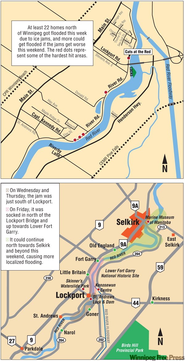
The river level at James Avenue in downtown Winnipeg fell to 17 feet above historical winter ice levels from 18.7 feet in the 24-hour period ending Friday morning, after an ice jam broke south of Lockport.
Ice jams, as well as continued ice on the Red, pose the most serious threats to the city, officials said. It’s possible water levels could reach 20.5 feet at James Avenue by April 3 if the ice hasn’t moved out of the city and the province is still unable to raise the floodway gates. But Warkentin said the city is prepared for that — and even a foot more water in south Winnipeg.
"The only thing that could upset the apple cart here is if we get an ice jam in the city. That would be bad news," he said.
Steve Topping, executive director of regulatory and operational services for the Water Stewardship Department, said the province is still preparing for a 1979-level flood, which would be the second worst in a century. The department, he said, is taking measures to break up ice at key points, such as near McIvor Road, north of the provincial trunk highway No. 4 bridge, as well as at the Portage Diversion at Lake Manitoba. Provincial officials said properties along the Assiniboine River in downtown Winnipeg aren’t immune from flood damage if ice remains on the Red into early April. The Red is already spilling into the Assiniboine, raising water levels on that river as far west as Assiniboine Park.
Meanwhile, Don Brennan, acting executive director with Manitoba’s emergency measures organization, said the province and affected municipalities he’s spoken to are confident they are prepared for the anticipated flood levels.
larry.kusch@freepress.mb.ca
Sightseers warned
LOOKIE-loos stay away.
That’s the word from politicians and the RCMP who are fed up with disaster tourists skirting road barriers and driving through floodprone areas north of Winnipeg.
St. Andrews Reeve Don Forfar said he’s worried volunteers, sandbag trucks, plows and even emergency vehicles will be stalled by voyeurs driving through to take a gander at the ice jam.
And Friday the RCMP issued a pointed reminder that failure to obey barricades might result in charges under the Highway Traffic Act.

A river of water woes
The chance of a 1997 level flood occurring this spring in Manitoba has diminished.
Ice jams still pose the greatest threat to Winnipeg and other communities along the Red.
Red River ice could clear the city as early as April 1, which would allow operation of the floodway. If the ice is still here on April 3, water levels could hit the high side of the range predicted for James Avenue (20.5 feet above historical winter ice levels).
Overland flooding in the Red River Valley will likely increase somewhat when the snow melts again early next week. The flooding is expected to continue for two to three weeks, even with favourable weather.
Ice jams on the Red between Lockport and Selkirk have been relatively stable since Thursday afternoon.
Related Articles
Tales of hope and kindness


Advertisement Advertise With Us
Advertisement Advertise With Us